The Role of UAVs in Mapping and the Transformation of the Industry
The advent of unmanned aerial vehicles (UAVs), commonly known as drones, has ushered in a significant transformation in the field of mapping. Traditionally, producing accurate maps required extensive time, heavy equipment, and large survey teams. Today, with drones equipped with high-resolution cameras and GPS systems, it is possible to collect vast amounts of geospatial data in a matter of hours.
This shift has not only accelerated the pace of mapping but also enabled surveying in remote or hazardous areas without requiring a physical presence. UAVs can fly at precise altitudes, capture high-resolution aerial imagery, and gather detailed topographical data. As a result, tasks that once took months can now be completed in just days—or even hours. This efficiency has prompted widespread adoption by private firms, government agencies, and infrastructure developers alike. Furthermore, digital transformation, artificial intelligence (AI), and geographic information systems (GIS) have collectively elevated the science of mapping to unprecedented heights.
The Key Advantage of UAVs: Unmatched Precision
Among the most notable advantages of UAVs in mapping is their superior accuracy. Thanks to advanced sensors, precision GPS units, and high-quality cameras, drones can capture georeferenced aerial imagery with remarkable detail. In civil engineering, infrastructure development, and land surveying, the accuracy of data is critical—minor miscalculations can lead to significant technical and financial consequences.
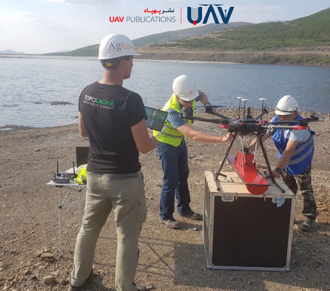
UAVs equipped with RTK (Real-Time Kinematic) or PPK (Post-Processing Kinematic) technologies can achieve centimeter-level precision. This makes them invaluable for cadastral mapping, monitoring topographic changes, and tracking project progress. Unlike traditional methods that rely on sampling specific points, UAVs can survey entire areas in detail, producing comprehensive models. Essentially, drones allow surveyors to see what was previously understood only through estimations. This enhanced precision increases confidence in the data and minimizes the need for repeated site visits.
Reducing Time and Costs in Construction Projects
Large-scale construction projects such as roads, dams, bridges, and high-rise buildings demand frequent, accurate, and efficient surveys. Drones have revolutionized this process by significantly reducing both time and cost. While traditional methods required survey crews to remain on-site for days or even weeks, drones can accomplish the same work within hours.
Additionally, fewer personnel are required, resulting in lower labor costs. Continuous monitoring via UAV allows engineers and project managers to track progress on a weekly—or even daily—basis. This reduces the need for repeated ground surveys, minimizes risks in hard-to-access areas, and eliminates the need for expensive traditional equipment.
Beyond aerial photography, drones are capable of video capture, 3D modeling, and calculating volumes of excavation or fill—all of which previously required considerable time and financial investment.
UAVs vs. Traditional Surveying Methods
Conventional surveying methods typically relied on total stations, theodolites, handheld GPS units, and levels. These techniques required time-consuming, point-by-point measurements and heavy human involvement. In contrast, UAVs automate the process, capturing data aerially and autonomously.
What would have taken several days using traditional tools can now be accomplished in a single drone flight lasting mere minutes, capturing thousands of high-resolution images. In challenging environments, such as mountains, swamps, or hazardous zones, traditional surveying is either impractical or prohibitively costly. Drones, however, gather comprehensive data without endangering personnel.
It is worth noting that traditional tools still have a place—for example, in underground or subsurface measurements. However, integrating drones with these conventional techniques often yields the most accurate and complete results. In sum, UAVs enhance speed, accuracy, and safety, rendering many traditional practices either obsolete or supplementary.
Applications in Agriculture and Environmental Mapping
Drones have found widespread use not only in civil engineering but also in agriculture and environmental monitoring. In farming, UAVs with multispectral imaging capabilities can assess crop health, soil moisture, and fertilization levels. These insights enable farmers to make informed decisions regarding irrigation, pest control, and harvesting, boosting efficiency while reducing costs.
In environmental science, drones serve as critical tools for monitoring forests, wetlands, water resources, and wildlife habitats. They can observe ecological changes or pollution without disrupting the natural environment. Drones are also invaluable during natural disasters—such as floods or earthquakes—offering rapid, accurate situational data to aid decision-makers in crisis response.
Thus, UAVs in mapping extend far beyond construction and play a vital role in resource conservation and sustainable agriculture.
From Raw Data to Precision Maps: Processing UAV Imagery
Raw data collected by UAVs is only valuable if properly processed. The transformation of aerial photos into precise maps involves several stages: georeferencing (assigning geographic coordinates), orthomosaic generation (correcting image distortions), and 3D modeling. Software such as Pix4D, DroneDeploy, and Agisoft Metashape is commonly used in these workflows.
Through photogrammetry algorithms, these platforms generate point clouds, digital elevation models (DEMs), and thermal maps. Incorporating GNSS data or ground control points (GCPs) can significantly improve map accuracy. The final outputs can then be exported to standard GIS formats and used in tools like ArcGIS or QGIS. Without this processing pipeline, UAV data remains incomplete and of limited practical value.
UAVs in 3D Modeling and Topographic Analysis
UAVs are particularly effective in creating three-dimensional models of both natural landscapes and artificial environments. These models are critical for terrain analysis, infrastructure planning, and design execution. By capturing images from multiple angles and applying photogrammetry, drones produce reliable models that reflect not just elevation but also volumes, slopes, and earthwork requirements.
Such 3D modeling is essential in mining, dam construction, route planning, and even the restoration of historical buildings. Drones can revisit the same site regularly to capture temporal changes, such as erosion, river migration, or urban expansion. This allows for visual and precise planning at every project stage.
Limitations and Challenges in UAV-Based Mapping
Despite their many advantages, drones in mapping face several limitations. Weather conditions pose the first hurdle—strong winds, rain, or fog can hinder operations. Battery life restricts flight duration, often requiring frequent recharging. Legally, many jurisdictions mandate licenses for drone operation, especially in urban or sensitive areas.
Data security, collision risk, and system failure are also significant concerns. Moreover, UAV data processing demands advanced hardware, software, and skilled personnel. Practical training, privacy compliance, and coordination with regulatory bodies are crucial for the responsible deployment of UAVs.
In short, while drones are powerful tools, their successful implementation requires appropriate infrastructure, training, and awareness of relevant regulations.
The Future of Mapping with UAVs and Artificial Intelligence
The fusion of UAV technology with artificial intelligence (AI) and machine learning (ML) is reshaping the future of geospatial analysis. Intelligent drones can autonomously plan flight paths, avoid obstacles, and optimize image capture angles to enhance their performance. AI algorithms can automatically interpret images, identifying roads, buildings, vegetation, and water bodies, dramatically reducing the need for manual data processing.
UAVs equipped with LiDAR sensors or multispectral cameras offer even deeper analytical capabilities. Additionally, integrating drones with cloud platforms allows real-time data processing and sharing. The future of mapping is intelligent, precise, and fast, with UAVs playing a central role.
Regulatory Standards for UAV Mapping Operations
To ensure the lawful and safe use of UAVs in mapping, adherence to aviation regulations and data governance standards is essential. In many countries, operators are required to hold a license, and drones must be registered with the national aviation authority. Restrictions apply to flight altitude, line-of-sight operations, and proximity to restricted areas, including airports, military zones, and residential neighborhoods.
In Iran, the Civil Aviation Organization oversees the licensing of UAVs, and operators are required to comply with aviation safety protocols. Because aerial mapping involves capturing images over land, it raises privacy concerns; therefore, ethical and legal principles must guide all data collection.
Complying with these standards not only ensures legal protection but also enhances data reliability and flight safety. Additionally, efforts are underway to integrate UAV-collected data into national GIS frameworks, further institutionalizing their role in modern mapping practices.